
Providing the Standard for Excellence in the Groundwater Tracing Industry Since 1973
Fluorescent Tracer Dye Specialists in Water and Land Use Investigations
417 785 4289
contact@OzarkUndergroundLab.com
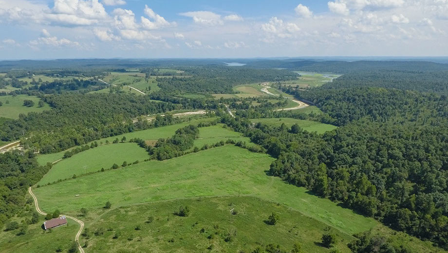
The Ozark Underground Laboratory consists of 2,900 acres of Ozark hill land overlying the 10,000 feet of known passage in Tumbling Creek Cave. The cave is a designated National Natural Landmark primarily because the fauna is the most diverse known for any U.S. cave west of the Mississippi.
The purposes of the Ozark Underground Laboratory are to encourage education, prudent resource use, and research in the cave regions of the United States. To do this, the Laboratory conducts educational field trips, is available for extended field studies, provides research facilities and assistance, and does consulting work and contract investigations on water and land use problems in cave regions.
The term "laboratory" may create an image of a sterile room with test tubes and people in white lab coats. That is not at all what the Ozark Underground Laboratory is about. A laboratory is a place where scientists and technicians do their work. Our work deals with the land, and our laboratory is a piece of the land which includes caves, springs, sinkholes, and other features.
Our goal is to improve the way people live with, and relate to, the natural resources of cave regions. Better public understanding of how the surface and subsurface interact is crucial to such improvements; this is the primary purpose of the educational field programs at the Laboratory.
At Tumbling Creek Cave our management is simple; it is based on the conviction that any action, which tends to maintain physical and biological integrity, stability, diversity and beauty is proper. Proper management must, to the extent of our knowledge and ability, take proper actions.
EDUCATION
Field trips to the Ozark Underground Laboratory are designed to complement and enhance college courses in the physical, biological, and earth sciences.
The field trips seek to stimulate questions and provoke discussions; conventional lectures are avoided as much as possible, but when given, are of an interpretive nature and at points where the group can readily observe the features under discussion. There is no standard lecture nor rigid timetable. The trips reflect the background and interests of the group members plus the features which can be observed at the time of the trip. Educational field trips are conducted year round in all kinds of weather, and overnight field trips are encouraged.
Field trips to the Laboratory consist of two segments. The surface tour typically requires about three hours; the underground tour takes two to three hours.
Educational field trips allow students to discuss current environmental problems with professionals who work with these problems daily. The Laboratory is the only facility of its kind in the United States, and its field trips provide a totally unique educational experience.
FIELD TRIPS
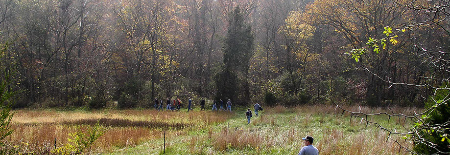
The two-mile long surface tour is usually conducted first. Relationships between the surface and the cave are stressed since the surface and the subsurface in cave regions are integrally tied together; differences or changes in the surface are reflected in the cave. For example, differences between the temperature and moisture conditions on north and south slopes are reflected in the surface vegetation as well as in the underlying cave system.
The surface at the Ozark Underground Laboratory includes typical north and south slope forest plant communities of oak and hickory. There are also some post oak flats (where most of the trees are post oaks, and are stunted due to shallow fragipan layers in the soil). There are some excellent "glades", characterized by eastern red cedar, a few hardwoods, and native grasses including big and little bluestem, Indian grass, and side oats grama.
THE SURFACE TOUR
An important way of relating surface conditions to the underlying cave is to consider how water enters the cave system. There are two types of groundwater recharge: discrete recharge and diffuse recharge. Discrete recharge occurs in very localized areas where substantial quantities of water enter the groundwater system. In contrast, diffuse recharge is small quantities of water entering the groundwater system from almost every point on the landscape.
A number of sinkholes and losing stream segments are visited on the surface tour. One sinkhole along the surface tour can channel at least 50 gallons of water per minute from the surface into the cave system. A losing stream segment in Bear Cave Hollow (the surface valley) has transported up to 500 gallons of water per minute from the surface into the cave. A disappearing stream is also visited which has been traced to the cave stream with dye, stained Lycopodium spores, and a bacteriophage (a virus which attacks a specific bacteria).
Two of the sinkholes at the Laboratory have been partially excavated to more clearly demonstrate that sinkholes are surface expressions of the underground drainage system.
The surface tour passes a pond where we consider similarities and differences between the energy levels of ponds and caves. One major difference is the lack of sunlight to furnish energy to the cave system. The primary source of energy for our cave system is bat guano from a summer colony of about 150,000 grey bats (Myotis grisescens). These bats eat about 1,000 pounds of bugs a night; this yields several hundred pounds of guano to the cave system each day the bats use the cave. One study at the Laboratory found guano to contain about 3.5 Calories per gram; this is approximately the caloric value of hamburger.
People living in cave regions often lack a workable understanding of how underground conditions affect surface activities and vice versa. For example, if you think that sinkholes and hydrologically similar features are adequate sites for waste disposal because you view the subsurface as an infinite filter, you or a neighbor may end up drinking sewage or trash from your spring or well. If, on the other hand, you more accurately understand the relationship of the surface and the subsurface, you can avoid many waste disposal blunders.
The surface tour endeavors to demonstrate the common characteristics of cave regions uncommonly well, and to identify the unique characteristics of the landscape.
The trail through Tumbling Creek Cave is 2,100 feet long. The purpose of the trail is to keep travel in the cave on a narrow, restricted route so that areas off the trail are kept in near-natural condition. There is no permanent lighting in the cave.
The cave has approximately two miles of mapped passages; field trips visit about 20% of the known cave. Travel into the remaining 80% of the cave is stringently restricted to protect the cave and cave fauna.
The Missouri Cave Resources Act is supported at the Ozark Underground Laboratory. Before entering the cave, ways in which people can harm the cave are identified and actions to prevent such damage are emphasized. Above all else, Tumbling Creek Cave is a unique and delicate place which will be protected by the staff of the Laboratory.
THE UNDERGROUND TOUR
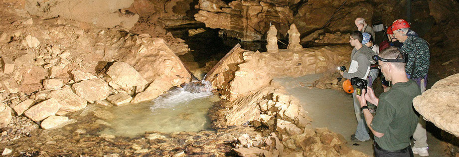
Passages in the cave display great diversity. Some chambers are huge; the Big Room is sixty feet high, 120 feet long, and 100 feet wide. Other passages are narrow and winding. In one place a 20-foot high waterfall cascades from the side of a chamber.
Several hundred feet of the trail is adjacent to Tumbling Creek, the underground stream. The cave stream drains an area of about seven square miles. The flow of the stream ranges from 0.1 cubic feet per second (cfs) to 100 cfs; flow is typically between 0.5 to 2.0 cfs. Low flows occur in late summer and early fall; high flows occur within a few hours of major surface storms. Occasionally, field trips are fortunate enough to be at the Laboratory during a major storm and get to see the torrents of water flowing through the cave system.
Secondary mineral deposits, particularly calcite, aragonite, hausmannite, and moon milk are found in much of the cave. Stalactites, stalagmites, draperies, columns, soda straws, rimstone dams, and other dripstone deposits of calcite and/or aragonite are abundant. Hausmannite is a manganese oxide mineral found coating rocks in the cave stream, on waterfalls, and at other points where surface waters rapidly enter the cave.
In some portions of the cave stalactites, stalagmites, and other cave formations are no longer depositing, but instead are being dissolved. Factors causing changes from deposition to solution are considered on field trips. These changes are commonly associated with surface events. This demonstrates that the cave is not a separate world, but instead is integrally tied to the surface and to conditions occurring on the surface.
Our cave fauna is very large and diverse. There are over 100 species known from the cave, and more will undoubtedly be discovered as more detailed work is conducted. Many are true cave dwellers (troglobites). Eight new or undescribed species, including a new genera of cave snail, have been found in this cave. Several animals found in the cave are on the Missouri Rare and Endangered Species List; some are also on the Federal Threatened and Endangered Species List. Several of these animals are usually seen on field trips.
On trips through the cave, time is spent observing and discussing the cave fauna. Some animals have very limited habitats within the cave; we typically discuss the impact of man's use of caves and the overlying land on cave fauna.
Caves are a food-poor environment for animals. However, a large fauna exists in Tumbling Creek Cave because of the guano from the summer bat colony of 150,000 grey bats. This colony is possibly the largest remaining summer colony of the grey bat in the U.S.
The office of the Ozark Underground Laboratory is maintained at the site, and is attached to the residence of Tom and Cathy Aley. The phone at the Laboratory Office may be used for emergency calls.
A field house is available to field trips. It has electricity, running water, a toilet and shower, a stove, cooking and eating utensils, a refrigerator, and a large fireplace.
A bunkhouse is also available. It has 18 very hard bunks, lots of floor space, and a small wood stove. A separate study room may be used by persons involved in detailed studies at the Laboratory. There are also two camping areas at the Laboratory.
A New Shower building is available with 3 showers, 3 toilets and 3 sinks to accommodate large overnight groups.
FACILITIES
WHAT TO BRING
Each person visiting the Ozark Underground Laboratory should bring rough clothes, comfortable boots or shoes with tread, a flashlight with new batteries, insect repellent from April through October, a raincoat, and food. Overnight visitors should bring a sleeping bag and foam pad.
FEES AND SCHEDULING
The Ozark Underground Laboratory is owned and operated by Tom and Cathy Aley, and receives its support from fees paid by users and visitors. Call or write for rates.
Field trip dates must be scheduled in advance. Minimum group size is 10 students, although smaller groups can be accommodated if we can schedule them with another small group. The optimum upper limit for trips is 30 students; this limit can be negotiated under special circumstances.
FEATURES OF INTEREST
Among the many interesting features found near the Laboratory are Bull Shoals Lake, the Mark Twain National Forest, the Hercules Glade Wilderness Area, Hodson Mill, and Old Dawt Mill. There are many lakes and streams for fishing, several nearby streams for floating and swimming, and several show caves.
NEARBY
1572 Aley Lane | Protem, Missouri 65733 | Phone 417-785-4289 | FAX 417-785-4290
© Copyright Ozark Underground Laboratory 2016